Deforestation (1.4.0)
Deforestation Simulation Model in NetLogo with GIS Layers
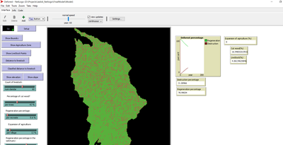
This model has developed in Netlogo software and utilizes the GIS extension. This NetLogo-based agent-based model (ABM) simulates deforestation dynamics using the GIS extension. It incorporates parameters like wood extraction, forest regeneration, agricultural expansion, and livestock impact. The model integrates spatial layers, including forest areas, agriculture zones, rural settlements, elevation, slope, and livestock distribution. Outputs include real-time graphical representations of forest loss, regeneration, and land-use changes. This model helps analyze deforestation patterns and conservation strategies using ABM and GIS.
Release Notes
This model has developed in Netlogo software and utilizes the GIS extension.
It simulates deforestation with parameters such as the number of animals, percentage of cut wood ,forest regeneration percentage , expansion of agriculture land percentage ,and the forest regeneration percentage in the sanctuary. It also includes spatial layers like forest area, agriculture zone in and rural area, livestock points, distance to livestock , elevation , and slope. This model was developed in 2017.
The model’s output includes a dynamic representation of the forest destruction and regeneration percentages, displayed graphically in real-time.
Associated Publications
This is a companion discussion topic for the original entry at https://www.comses.net/codebases/5ed6b4f1-8a59-4dc5-b949-38ca381144cf/releases/1.4.0